 |
Mt. Washington Temp.
Click pic for forecast.
| ...More Topics... |
 Books Books |
| Bulletin Board |
| Clubs & Huts - AMC Huts |
| Feedback |
| 4,000 footers |
| Hiking Glossary |
| Mail List |
| Privacy Policy |
| Store |
| Weather |
| Search |
|
|


![]()
![]()


Basin-Cascades, Cascade Brook, Kinsman Pond, Kinsman Ridge, and Fishin' Jimmy Trails
by Chris

Spring was in the air in NH which meant a couple things. One, it was time for the annual Flags on the 48 planning meeting and two that I needed to go hiking! Dome was on board with my little plan, so we mirrored last year's plan by packing up his camper and heading up to the Broken Branch campground.
This year the rain was particularly fierce, we had broken many of the previously held rainfall records and we were still getting showers about every other day. With this in mind, Dome and I decided we should tackle a viewless peak. But wait, you think, the Kinsmans are not viewless! You're right, we suck at sticking to a plan. We're men!
Despite the crappy forecast (rain was predicted all day) we packed up our stuff and headed to the Basin Cascades trailhead. We picked the Kinsmans because of their proximity to the Broken Branch (we did Cannon last year. Coincidence? I think not.) so it was only about a 15 minute ride and we were at the parking lot for The Basin. We took five minutes to gather our gear and started on our way.
It's not entirely clear where you need to go out of the parking lot, so we walked around a little and discovered that we needed to walk through the underpass of Route 3/93 to get to the Basin, which is where the trail begins. Signage was poor, and we took a nice tour of the Basin and its surrounding area before finding the trailhead (which was marked by a pretty big sign, but you had to look for it). At about 9:45 AM we hit the trail for real.

The topo for this hike revealed that there were moderate grades, which we always find is a great way to warm up, and that's what we got. The Basin Cascades trail starts wide with good footing. Many people travel this section of trail because it follows the Cascade Brook for almost its entire length, and there are numerous scenic areas that attract non-hikers. We stopped frequently along the first half mile of trail to take pictures. The recent rains had produced unusual volumes of water which were enticing to us, although not great for serious photographers according the serious photographer we met (too much white apparently).
By the time we had covered about .6 mile, we were at our first water crossing. Now I've read countless reports and musings about how certain crossings "could be difficult or dangerous at high water" and had never really paid much attention. Well, I guess I'm born again, because this was about the highest water this brook would see for some time, and it was definitely what I'd call difficult. The stones that would provide an easy walk across the brook in drier conditions we now six inches under water that was moving very rapidly. Having not been smart enough to bring my sandals (I even knew I would need them, but it's not a trip unless I forget something important) Dome and I decided he would cross first and toss me his Teva's so I could follow, which is what we did. After about a ten minute effort, we made it across some seriously cold water, dried off and began up the trail again.

At precisely one mile, we met up with the Cascade Brook trail which meets the Basin Cascade at a very out of place fiberglass bridge. (Don't get me wrong, I was grateful for the bridge, but it just looked, well, wrong.) As we ascended the Cascade Brook Trail, we noticed very little difference in the grade, and in fact continued to follow the Cascade Brook. Another .1 mile up we found ourselves in a very unique landscape marked by the fact that it was relatively flat and mossy. Another 100 feet up we saw the Rocky Glen Falls, which was stunning. We stopped for a few shots and to admire the falls (which of course were surging with storm water) before continuing up the trail.
Shortly after Rocky Glen Falls, we were treated to another brook crossing, this one we were able to make without boot removal and continued up trail. One half mile from where we connected with the Cascade Brook trail, we left it to join the Kinsman Pond trail. For this, we were met with yet another crossing, for which we were required to remove our boots once again, which we grudgingly did. I opted to go barefoot for this one, and it worked out fine. I know, I'm sure you were concerned.
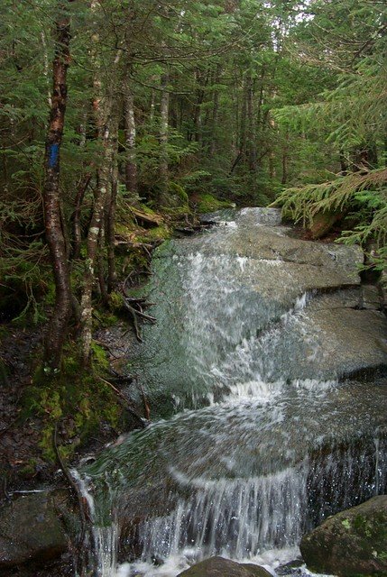 Look carefully, you'll see the blue blaze on the left indicating the trail. |
Feeling a little energized, we moved steadily up the Kinsman Pond trail. A look at the topo from the White Mountain Guide showed no water sources that paralleled the trail, but we were definitely walking by a brook. In fact, the trail and the brook became one for quite a while, which made this a tough and somewhat slow trek, especially in the high water. We both commented about how beautiful this section of the trip was because the forest was thick with moss and other greenery that is rare in the Whites. Despite the rough footing and very wet conditions we made it to the Kinsman Pond, now 3.6 miles into our trip, in about three hours.
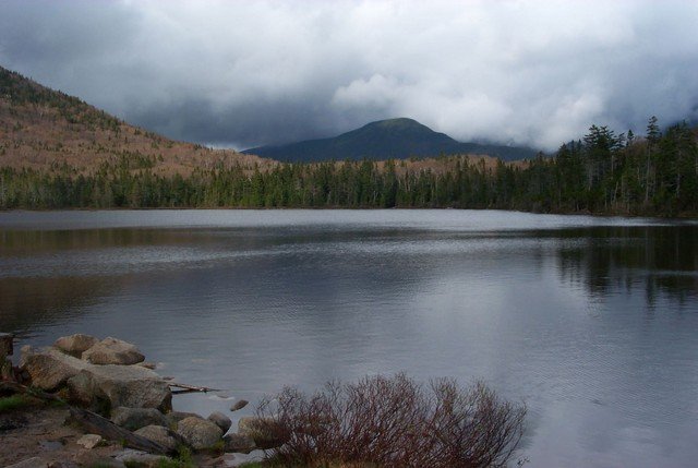
The clouds that defined this day were still present, but they could not diminish the beauty of Kinsman Pond. Like many higher ponds, this one was clear and gorgeous, long and somewhat narrow. Dome imagined bringing his son up for some fishing in a few years and I thought that sounded like a great idea. We caught a couple glances at the peak of North Kinsman, which look formidable from the pond, but quickly decided it wouldn't be as bad as it looked.
We followed the trail around the east side of the pond and arrived at the Kinsman Pond shelter, which was deserted. The shelter is in good condition and can hold about 12 people without getting too cozy. There's water near by (requires treatment) and even several tent platforms within a few hundred feet. We were not interested in staying long, so we covered the .1 mile to reach the Kinsman Junction, where we ran into the first humans we'd seen since the beginning of the Basin-Cascade Trail.
We chatted quickly with a nice couple (French Canadians who had brought the wrong map but hiked anyway [don't do this at home kids!]) and moved on to the Kinsman Ridge Trail which would take us to the peaks. The grade increased pretty quickly as we began the summit push, but was never very tough. The usual rocky footing and occasional granite slab slowed us down a bit, but within 30 minutes, we were at the summit North Kinsman, looking into a giant white wall of clouds.


There's a very short diversion off the peak to a ledge overlooking Kinsman Pond, which we imagined would have some great views if we could see. As soon as we got there the rain picked up and conditions were what we like to call less than optimal. A quick bite to eat and we were off to South Kinsman.
The Kinsman Ridge Trail noticeably descends immediately off the summit area and drops into a thickly wooded section, but soon after the trail levels then begins its climb to South Kinsman. We were getting a little tired at this point, and there was little notable about the trail so we pretty much marched in silence. By the time we got to the summit of South Kinsman, it was 1:30 and the clouds had not given us any views at all. We were disappointed at the lack of views, but were psyched we put another two 4K's into the books. After a quick picture and some chow, we headed back towards North Kinsman.


Retracing your steps is not as much fun as exploring new places, but in this case it worked out ok. When we reached North Kinsman again, the clouds cleared enough for us to get a couple quick pictures of the available views. We stuck around long enough to meet a solo hiker from the AMC, then made our way back to the Kinsman junction, where we had a decision to make.
All along, we thought about what route to take back. We had the option to use the same trails, or branch out and take the Fishin' Jimmy Trail (part of the AT) so we could see Lonesome Lake and the AMC Hut there. It took us 30 seconds to choose alternate route, and off we went.
The Fishin' Jimmy Trail, from this direction, looked very comfortable at first. Good footing, lots of log bridges over wet areas, and even room to pass other hikers (we saw several ill-prepared groups heading up to the shelter). But the grade quickly started to increase, and we found ourselves descending a pretty steep trail that were we glad we did not have to ascend. Travel was slower than we would have liked, partially because of the wet trail, mostly because my knee was screaming with every step, but we pressed on and made it down to Lonesome Lake and the Lonesome Lake shelter in about an hour.
Lonesome Lake is another gorgeous lake nestled into a fantastic location. We could easily understand why the AMC wanted this spot for a hut. We shot some quick pictures, but Dome and I were both anxious to get moving. This trip was taking longer than expected and we were flirting with the dinner hour at this point, so we moved on quickly.
As we left Lonesome Lake, we almost took the Cascade Brook path in the wrong direction. My last second glance at the signs set us straight and we headed back towards the Basin Cascade Trail. By 5:45 PM we were back at the car and ready for a hot shower and some grilled steaks. The trip took eight hours including photo opportunities, rest, and river crossings; more than we expected, but when we thought about it, seemed reasonable given the 9.9 mile total trip and difficulties associated with the heavy rains. But in the end, we both thoroughly enjoyed the fantastic scenery (especially the first half of the route) and the variety of landscape along the route.

Chris Oberg & Robert Havasy
Hike-NH.com